Welcome to the IKCEST
Login
|
Register
English
中文
Search
Advanced search
Navigation
Home
Document
Post
Reports
Newsletters
Data
Subject database for earthquake
Subject database for drought
Subject database for flood
Subject database for frozen
Subject database for heat wave
Subject database for wild fire
Subject database for ecology & environment
Subject database for urban
Subject database for social media mining
Subject database for hurricane disaster
Regional basic database for the Belt and Road
Regional disaster database for the Belt and Road
Regional database for China-Mongolia-Russia Economic Corridor
Regional database for China-Pakistan Economic Corridor
Regional database for Bangladesh-China-India-Myanmar Economic Corridor
Maps
China Historical Disaster
Biological Disasters
Geological Disasters
Earthquake Disasters
Meteorologic Disasters
Flood Disasters
Raster Data
Vector Data
Education
Tutorial for GIS
Disaster Knowledge
Presentation
Training Video
Reference report
Disaster news Video
Science Popularization
International Training
Subject-Catalogue
Organization
Experts
Website
Application
Information Aggregation
Application Using Web GIS
Scientific Data Visulization
Natural Science Research Work
Emergency Disaster Mitigation Services
Directory
Scholar
ALL
Earthquake
Flood
Drought
Geological disaster
Forest fire
Tsunami
Extreme heat wave
Typhoon
Disaster warning
Disaster risk reduction
Sichuan-Tibet Railway
Home
Subject database for earthquake
Publish Data Data
Subject database for earthquake
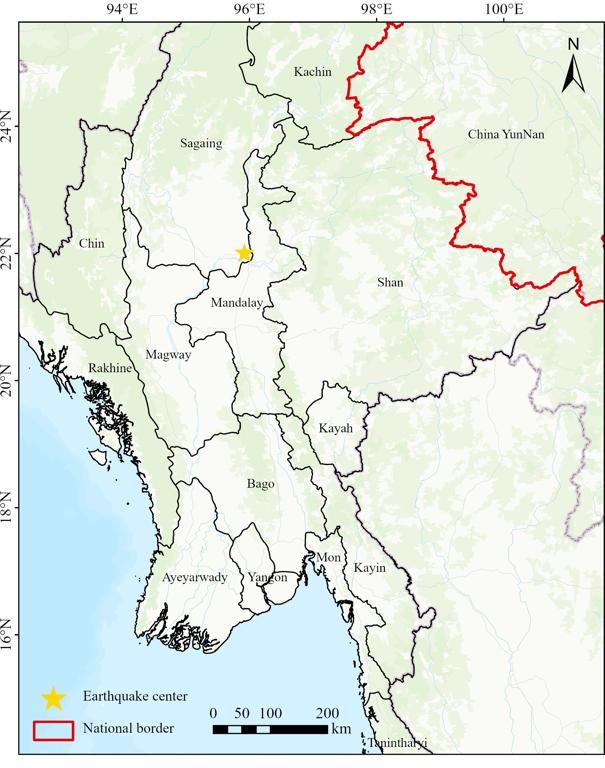
Location of the epicenter of the March 28, 2025 Myanmar earthquake
epicenter
Myanmar earthquake
2025-04-02
This data can be obtained in Shapefile format. This data shows that the Myanmar earthquake, which occurred on March 28, 2025, cent...
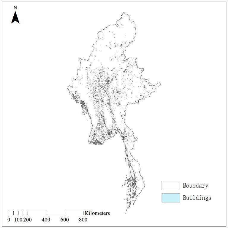
Spatial distribution of buildings in Myanmar
building
Myanmar
2025-04-02
The data is based on high resolution imagery and deep learning segmentation algorithms to obtain information on building contours ...
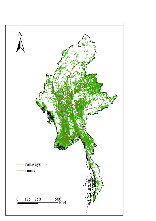
Spatial distribution of the Myanmar road traffic
road traffic
railway
2025-04-02
This dataset is road network data from OpenStreetMap, including railways, motorways, gravel roads, cycle paths, footpaths and more...
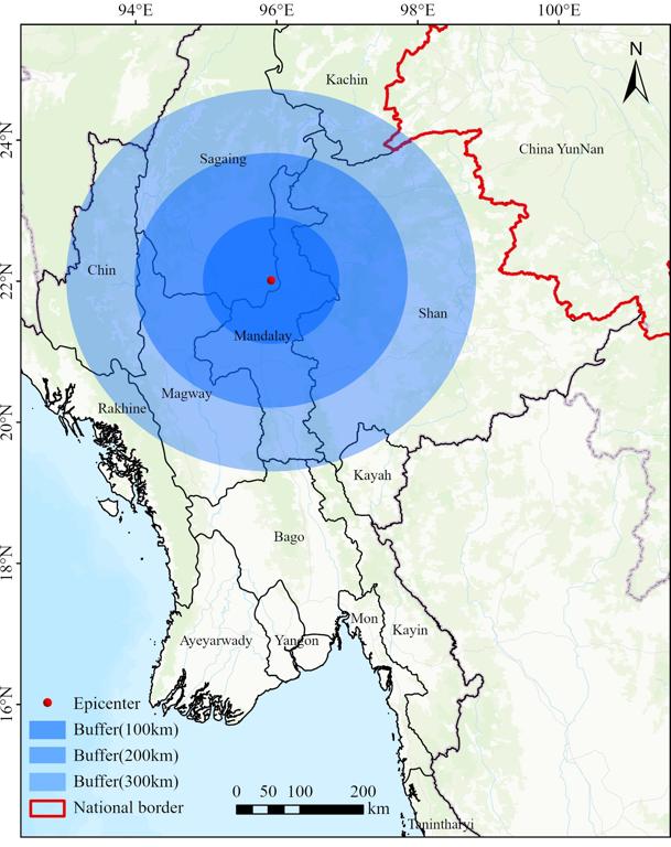
Myanmar earthquake epicentre multilevel buffer range data (100km/200km/300km)
buffer area
Myanmar earthquake
2025-04-02
This dataset is presented in Shapefile format. It leverages earthquake center location data supplied by the United States Geologi...
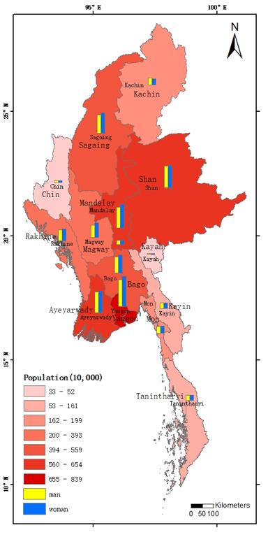
Population spatial distribution data of Myanmar
Population
Myanmar
Provincial
2025-04-01
This dataset is based on a report by The Mirror of Myanmar on 2 April, in which the Population Division of the Ministry of Labour,...
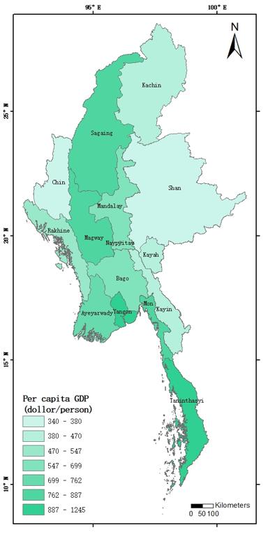
Spatial distribution data of GDP per capita in Myanmar
Per capita GDP
Myanmar
Provincial
2025-04-01
This dataset is based on the Economic Development Plan submitted by the Ministry of Finance of Myanmar for 2018 to 2019, and the G...
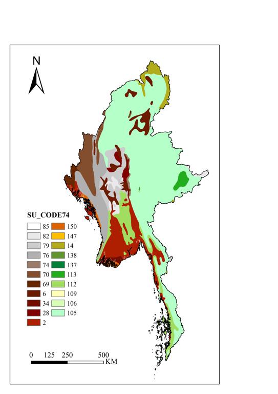
Myanmar soil distribution data
soil
soil types
2025-04-01
The dataset is available to download in Geotiff format at a resolution of 30 arc-second (approximately 1000m at the equator). It p...
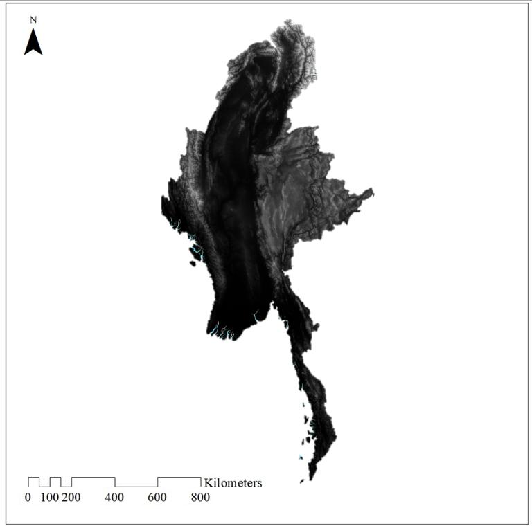
DEM of Myanmar
DEM
Myanmar
2025-04-01
The dataset was downloaded from GEE, derived from SRTM (Shuttle Radar Topography Mission) published by NASA. It is available in im...
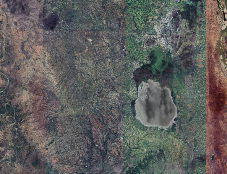
Myanmar high resolution images in the earthquake zone
Remote Sensing
High Resolution
2025-04-01
The dataset is a high-resolution remote sensing image of the epicenter of Mandalay, Myanmar with a spatial resolution of 8 meters ...
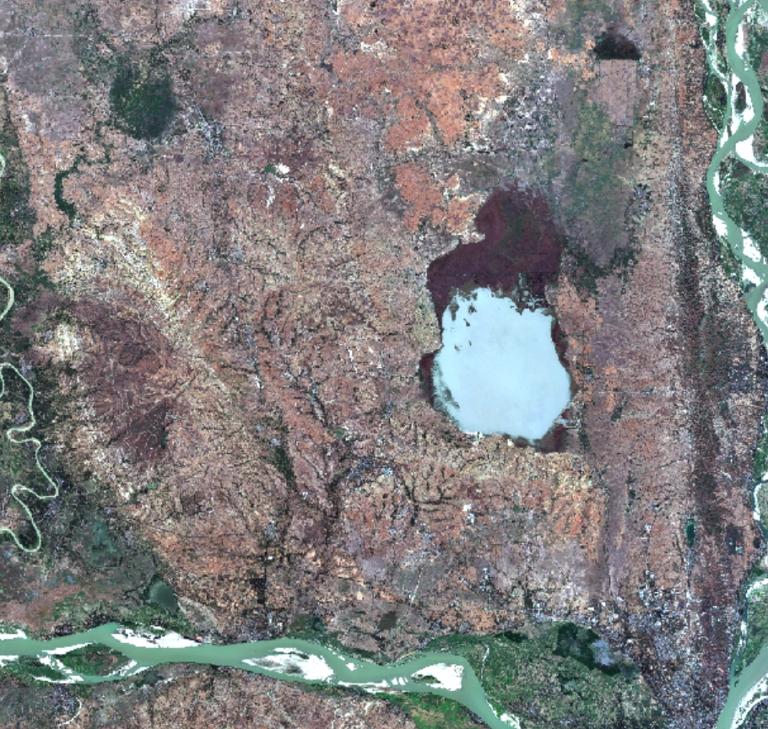
Image of Sentinel 2 in the earthquake zone of Myanmar
Sentinel 2
Mynmar
Remote Sensing
2025-04-01
The dataset is a Sentinel 2 multispectral image before the earthquake in Myanmar, with a spatial resolution of 10m, and the data h...
1
2
3
4
5
6
Next page
End
Most concern
Leaf Area Index (LAI): Field Measurements, Remote Sensing Estimation and Validation Studies(2015)
Resources, Environmental and Economic Patterns and Sustainable Development Modes of Silk Road Economic Belt(2015)
The disaster scene of zhouqu mudslide in gansu province
Ecosystem, Climate and Livehood
Spring Festival travel during ice disaster in 2008
Recent articles
2026-06-24: M7.5 Venezuela Earthquake
A dataset of spring sandstorm distribution on the Mongolian Plateau (2000-2021)
China Earthquake Administration
Institute of China Seismological Bureau crustal
Cui Peng
Classified catalogue
Presentation
Training Video
Reference report
Paper
Disaster news Video
Documents
Books
Journal
Data
Subject database for hurricane disaster
Portal
Experts
Organization
Website
Biology
Climatology
Geophysics
Hydrology
Meteorology
Technology
Subject database for earthquake
Subject database for drought
Subject database for flood
Subject database for frozen
Subject database for heat wave
Subject database for wild fire
Subject database for ecology & environment
Subject database for urban
Subject database for social media mining
Regional basic database for the Belt and Road
Regional disaster database for the Belt and Road
Regional database for China-Mongolia-Russia Economic Corridor
Regional database for China-Pakistan Economic Corridor
Regional database for Bangladesh-China-India-Myanmar Economic Corridor
Data List
|
About
|
Contact Us
|
How to use
京ICP备05002838号-31
© 2008 - 2024 IKCEST All rights reserved