Welcome to the IKCEST
Login
|
Register
English
中文
Search
Advanced search
Navigation
Home
Document
Post
Reports
Newsletters
Data
Subject database for earthquake
Subject database for drought
Subject database for flood
Subject database for frozen
Subject database for heat wave
Subject database for wild fire
Subject database for ecology & environment
Subject database for urban
Subject database for social media mining
Subject database for hurricane disaster
Regional basic database for the Belt and Road
Regional disaster database for the Belt and Road
Regional database for China-Mongolia-Russia Economic Corridor
Regional database for China-Pakistan Economic Corridor
Regional database for Bangladesh-China-India-Myanmar Economic Corridor
Maps
China Historical Disaster
Biological Disasters
Geological Disasters
Earthquake Disasters
Meteorologic Disasters
Flood Disasters
Raster Data
Vector Data
Education
Tutorial for GIS
Disaster Knowledge
Presentation
Training Video
Reference report
Disaster news Video
Science Popularization
International Training
Subject-Catalogue
Organization
Experts
Website
Application
Information Aggregation
Application Using Web GIS
Scientific Data Visulization
Natural Science Research Work
Emergency Disaster Mitigation Services
Directory
Scholar
ALL
Earthquake
Flood
Drought
Geological disaster
Forest fire
Tsunami
Extreme heat wave
Typhoon
Disaster warning
Disaster risk reduction
Sichuan-Tibet Railway
Home
Regional database for China-Pakistan Economic Corridor
Publish Data Data
Regional database for China-Pakistan Economic Corridor
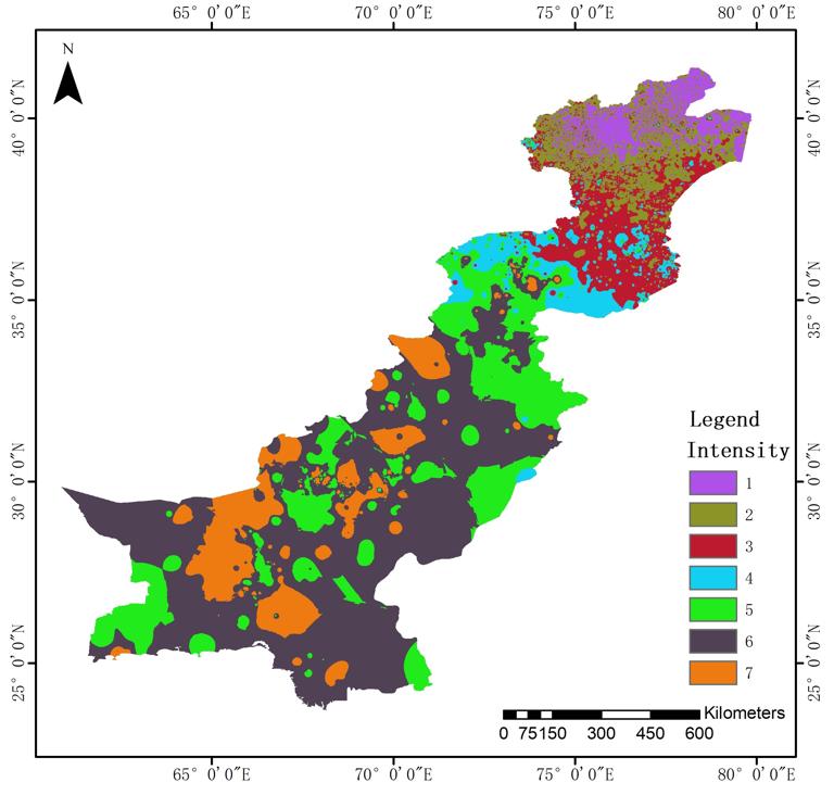
Magnitude, intensity, and ground motion peak acceleration of 1000-meter earthquakes in the China-Pakistan Economic Corridor from 1960 to 2000
Ground motion peak
China-Pakistan Economic Corridor
Earthquake magnitude
Intensity
2025-02-19
This dataset is 1000-meter earthquake magnitude, intensity, and peak ground shaking acceleration data of the China-Pakistan Econom...
Dataset of extreme warming processes on the eastern Pamir Plateau at the northern end of the China Pakistan Economic Corridor from 1961 to 2017
Climate
China Pakistan Economic Corridor
Pamir Plateau
2025-02-18
The China-Pakistan Economic Corridor (CPEC) through the Pamirs Plateau, with the terrain complex and fragile ecological environmen...
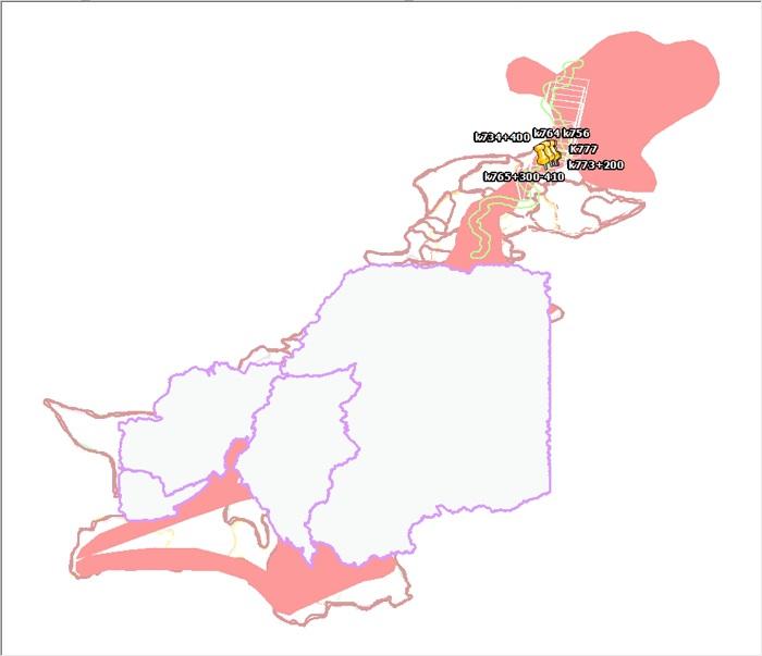
A dataset of surface deformation along the China-Pakistan Economic Corridor from 2014 to 2018
Surface deformation
China-Pakistan Economic Corridor
InSAR
2025-02-18
Based on time-series InSAR technology, the surface deformation data covering all areas of the China-Pakistan Economic Corridor (CP...
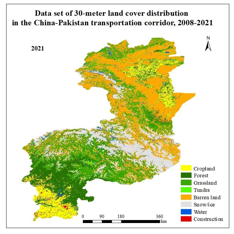
Data set of 30-meter land cover distribution in the China-Pakistan transportation corridor, 2008-2021
Land cover distribution
China-Pakistan Transportation Corridor
2023-01-10
This dataset is a 30-meter land cover distribution dataset for the China-Pakistan transportation corridor from 2008 to 2021, wit...
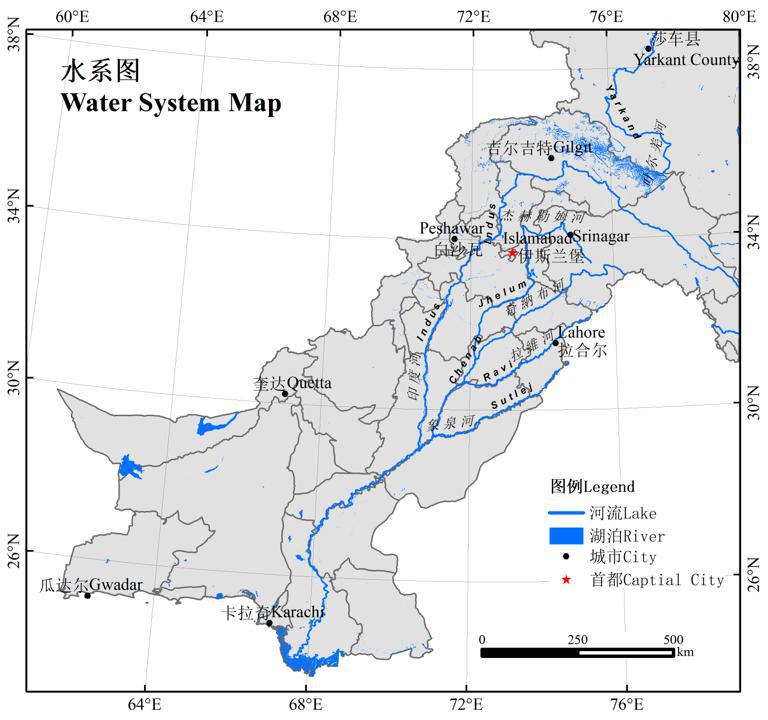
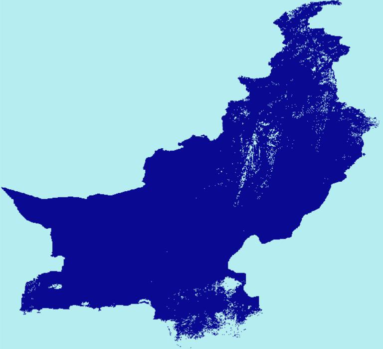
Pakistan's water system dataset (2022)
water system
Pakistan
2022-09-20
The Pakistan's water system dataset is made by using the water system distribution data downloaded from the DIVA-GIS official we...
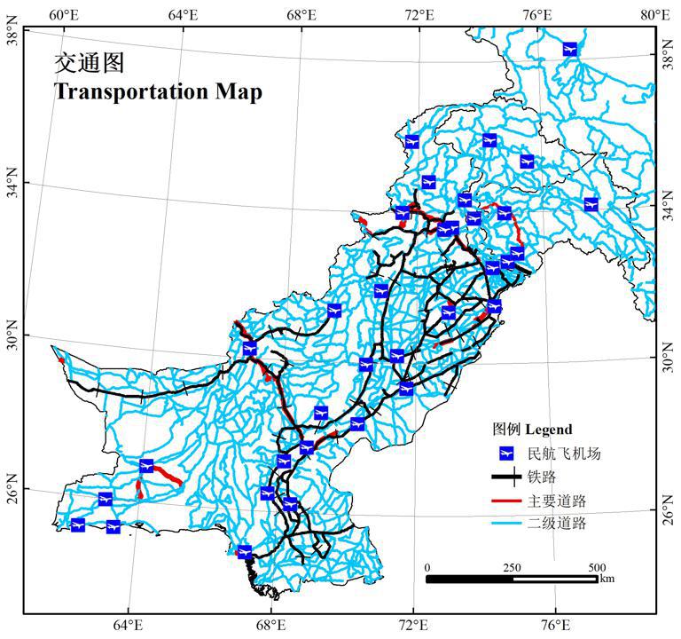
Pakistan's traffic network dataset (2022)
traffic networ
Pakistan
2022-09-20
The Pakistan's traffic network dataset is made by using the water distribution data downloaded from DIVA-GIS official website....
Pakistan surface water dataset (2020)
surface water
Pakistan
2022-09-20
Pakistan surface water dataset is cut from JRC global surface water distribution. Use Google Earth engine to select the image ...
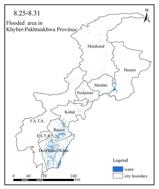
Dataset of water body distribution in Khyber Pakhtunkhwa, Pakistan(2022/8)
water body distribution
Pakistan
2022-09-20
The data source is Sentinel1 imagery. The water body indices of SAR images were constructed to obtain the water body distributi...
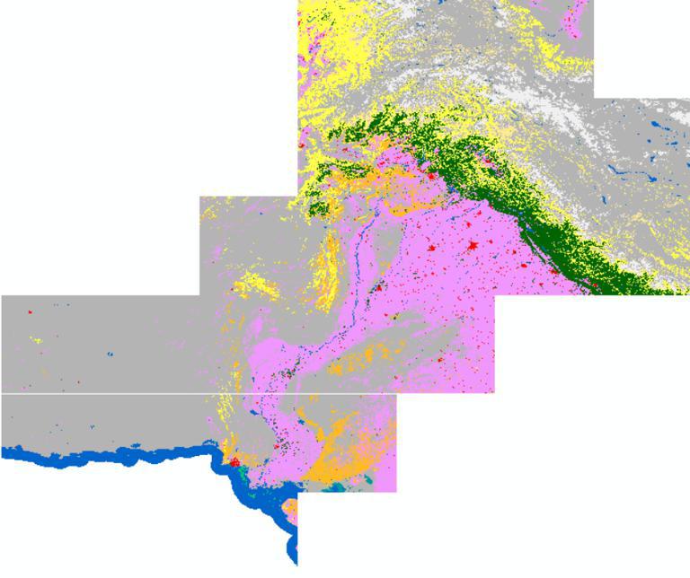
Pakistan Land Cover Dataset
Land Cover
Pakistan
2022-09-20
The data source is ESA land cover data on the GEE platform. The data were obtained by clipping. Its spatial resolution is 10m....
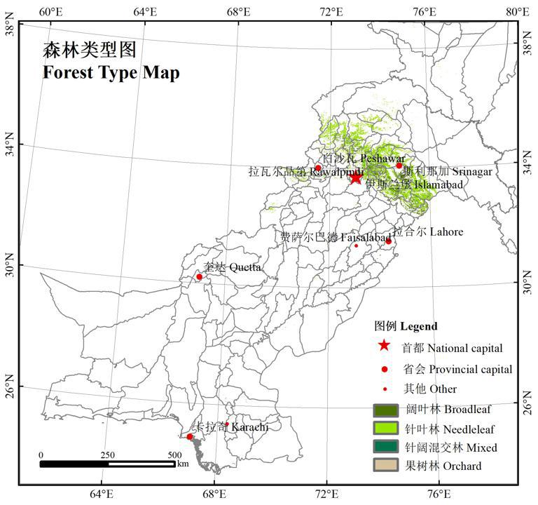
Pakistan Forest Distribution Dataset
Forest Distribution
Pakistan
2022-09-20
The data source is ESA land cover data on the GEE platform. The data were obtained after filtering the forest type land. Its s...
1
2
3
4
Next page
End
Most concern
Leaf Area Index (LAI): Field Measurements, Remote Sensing Estimation and Validation Studies(2015)
Resources, Environmental and Economic Patterns and Sustainable Development Modes of Silk Road Economic Belt(2015)
The disaster scene of zhouqu mudslide in gansu province
Ecosystem, Climate and Livehood
Spring Festival travel during ice disaster in 2008
Recent articles
2026-06-24: M7.5 Venezuela Earthquake
A dataset of spring sandstorm distribution on the Mongolian Plateau (2000-2021)
China Earthquake Administration
Institute of China Seismological Bureau crustal
Cui Peng
Classified catalogue
Presentation
Training Video
Reference report
Paper
Disaster news Video
Documents
Books
Journal
Data
Subject database for hurricane disaster
Portal
Experts
Organization
Website
Biology
Climatology
Geophysics
Hydrology
Meteorology
Technology
Subject database for earthquake
Subject database for drought
Subject database for flood
Subject database for frozen
Subject database for heat wave
Subject database for wild fire
Subject database for ecology & environment
Subject database for urban
Subject database for social media mining
Regional basic database for the Belt and Road
Regional disaster database for the Belt and Road
Regional database for China-Mongolia-Russia Economic Corridor
Regional database for China-Pakistan Economic Corridor
Regional database for Bangladesh-China-India-Myanmar Economic Corridor
Data List
|
About
|
Contact Us
|
How to use
京ICP备05002838号-31
© 2008 - 2024 IKCEST All rights reserved