Welcome to the IKCEST
Login
|
Register
English
中文
Search
Advanced search
Navigation
Home
Document
Post
Reports
Newsletters
Data
Subject database for earthquake
Subject database for drought
Subject database for flood
Subject database for frozen
Subject database for heat wave
Subject database for wild fire
Subject database for ecology & environment
Subject database for urban
Subject database for social media mining
Subject database for hurricane disaster
Regional basic database for the Belt and Road
Regional disaster database for the Belt and Road
Regional database for China-Mongolia-Russia Economic Corridor
Regional database for China-Pakistan Economic Corridor
Regional database for Bangladesh-China-India-Myanmar Economic Corridor
Maps
China Historical Disaster
Biological Disasters
Geological Disasters
Earthquake Disasters
Meteorologic Disasters
Flood Disasters
Raster Data
Vector Data
Education
Tutorial for GIS
Disaster Knowledge
Presentation
Training Video
Reference report
Disaster news Video
Science Popularization
International Training
Subject-Catalogue
Organization
Experts
Website
Application
Information Aggregation
Application Using Web GIS
Scientific Data Visulization
Natural Science Research Work
Emergency Disaster Mitigation Services
Directory
Scholar
ALL
Earthquake
Flood
Drought
Geological disaster
Forest fire
Tsunami
Extreme heat wave
Typhoon
Disaster warning
Disaster risk reduction
Sichuan-Tibet Railway
Home
Subject database for ecology & environment
Publish Data Data
Subject database for ecology & environment
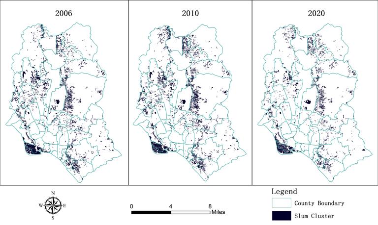
Fine-scale urban informal settlement time series distribution data set of Dhaka, Bangladesh
urban informal settlement
Dhaka
Bangladesh
2025-02-19
This fine-scale urban informal settlement time series distribution data set in Dhaka, Bangladesh provides the distribution of info...
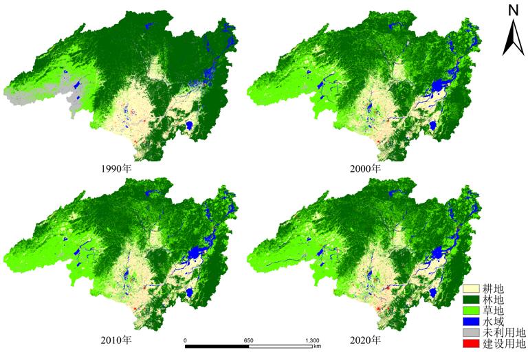
Data set of land cover within 30 meters of Amur River Basin from 1990 to 2020
land cover
Amur River Basin
2025-02-19
The Amur River Basin is a region with great potential for food production in Northeast Asia, and land cover is one of the importan...
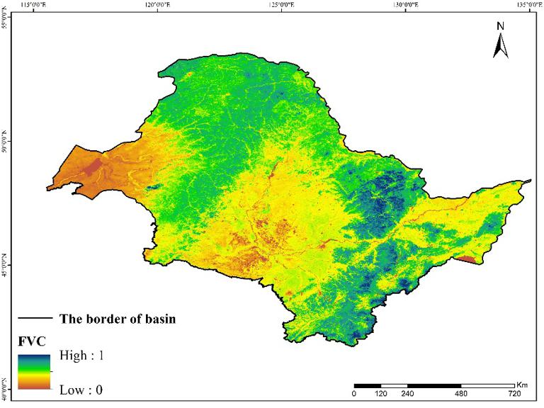
Fractional vegetation cover dataset in Amur River Basin (China) (2001-2019)
Spatio-temporal Distribution
Fractional vegetation cover
2022-11-01
This dataset described the spatial distribution of fractional vegetation cover in the Amur River basin (China), which includes H...
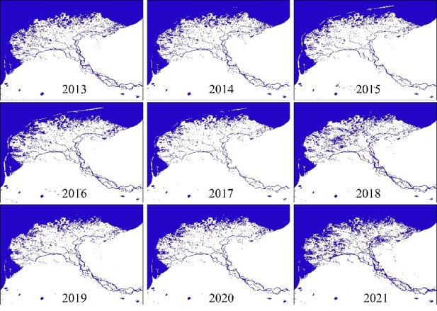
Data set of surface water body distribution within 30 meters of Baikal Lake basin from 2013 to 2021
Mongolia
Mongolian Plateau
vegetation phenology
2022-09-28
This data set is a 30 meter surface water body distribution data set in the Baikal Lake basin from 2013 to 2021. It has 9 phases...
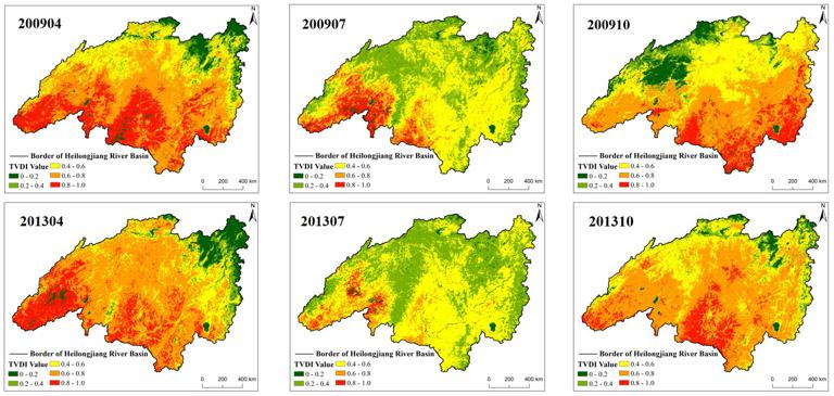
Temperature Vegetation Dryness Index 1-km Grid Dataset in Amur River Basin (2007-2018)
Amur River Basin
Spatio-temporal Distribution
2022-09-28
This dataset described the spatial distribution of temperature vegetation dryness index in the Amur River basin, which is a cros...
Land degradation and restoration data set in Mongolia from 2015 to 2020
Land degradation
China-Mongolia Railway (Mongolia section)
2022-09-07
This data set is the land degradation and restoration data set in Mongolia from 2015 to 2020. It mainly records the types of land ...
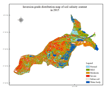
Soil salinization data set with 30m spatial resolution in the Yellow River Data
Soil
salinization
2022-09-07
Based on landsat8 oil multispectral data with 30 meters spatial resolution in 2015 and 2019, the soil salinization degree data set...
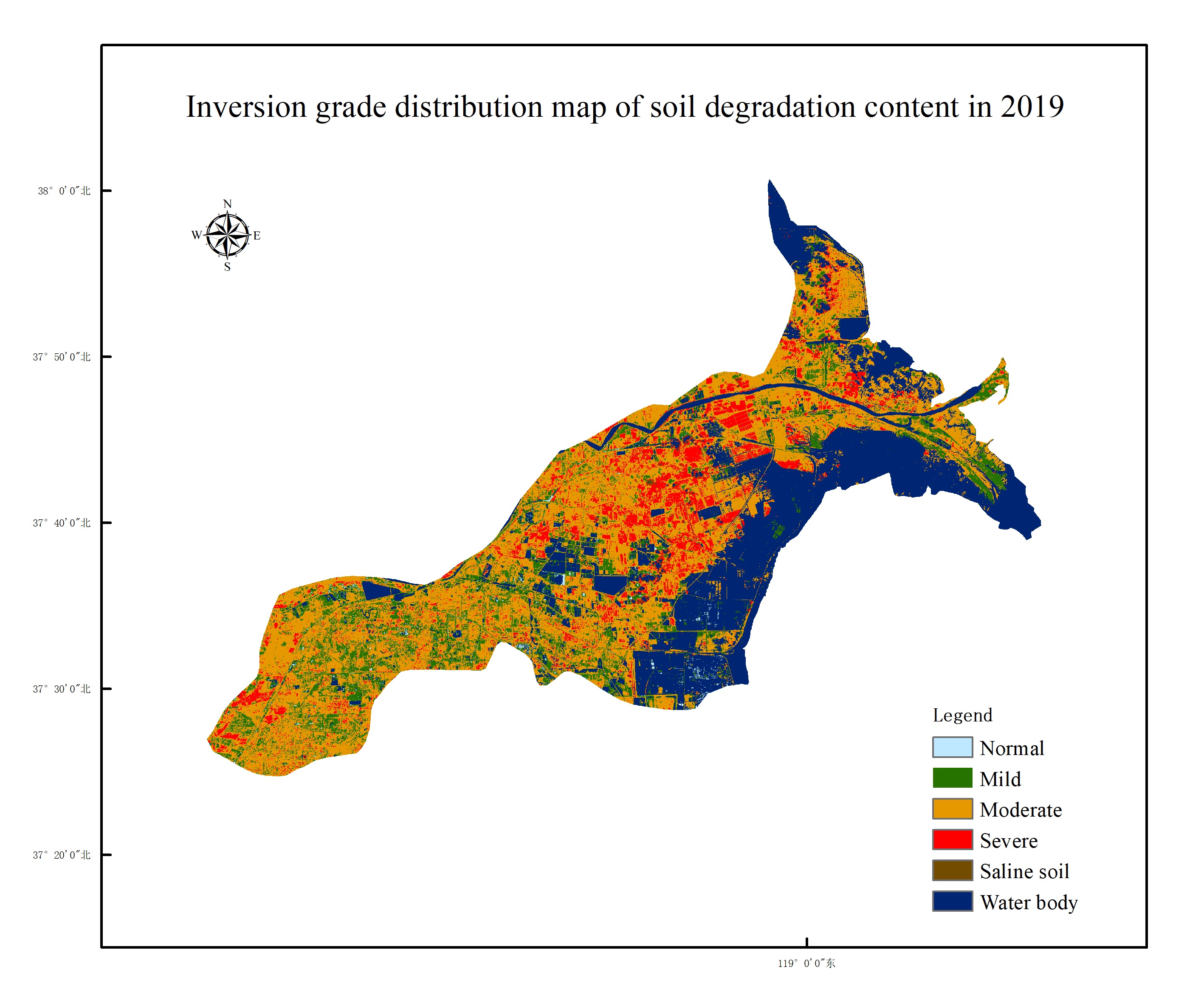
Soil degradation data set with 30 m spatial resolution in the Yellow River Delta
Soil degradation
Yellow River
2022-09-07
Based on landsat8 oil multispectral data with 30 meters spatial resolution in 2015 and 2019, the data set of soil degradation degr...
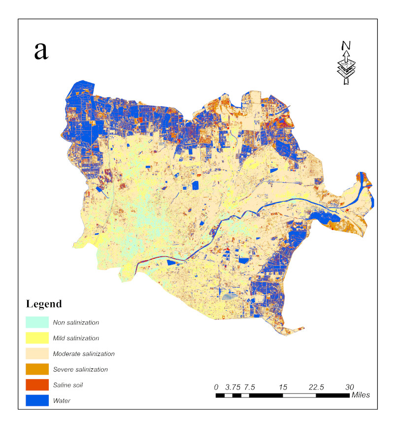
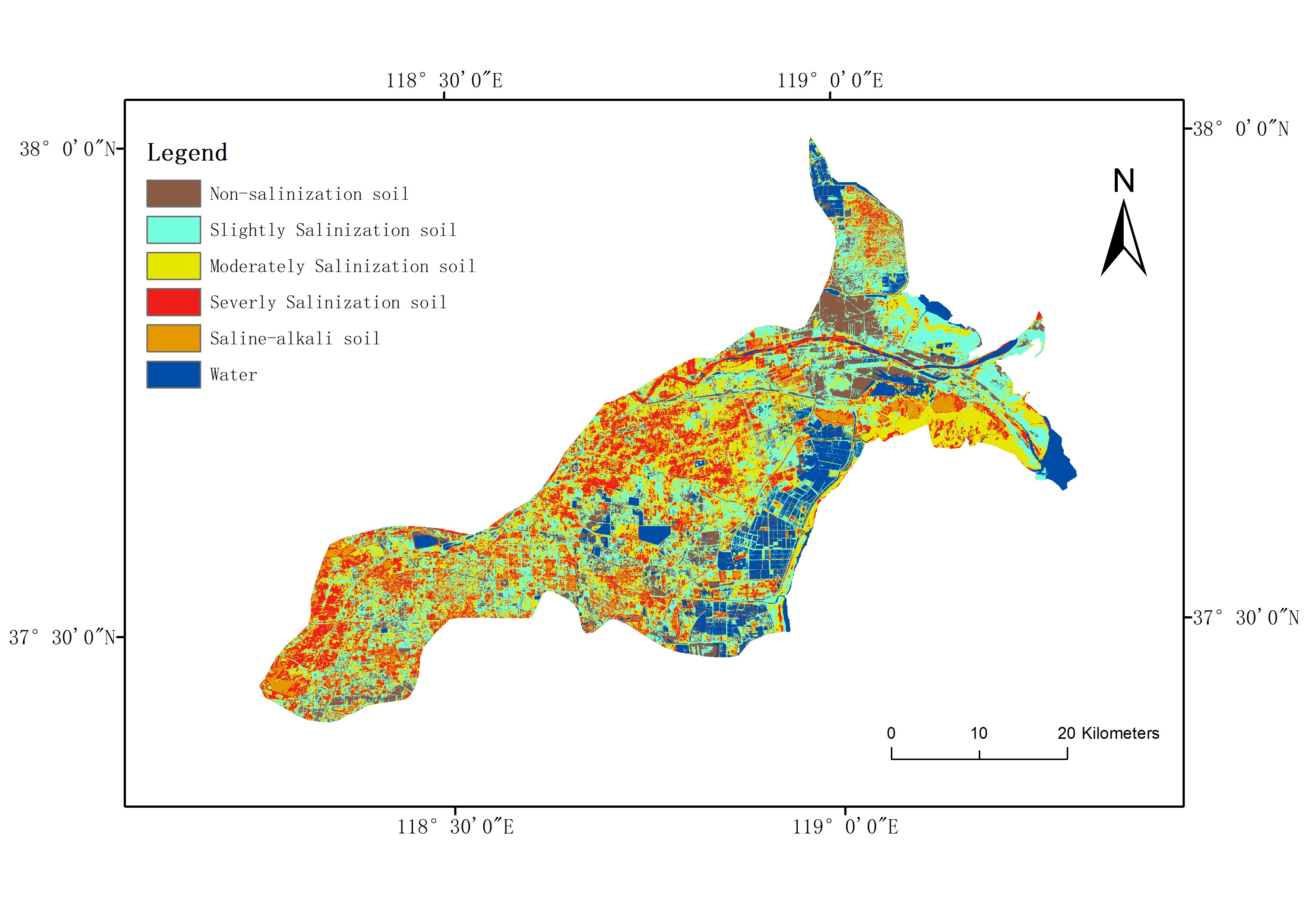
Dataset of soil salinization in the lower Yellow River and coastal cities(2015-2020)
Soil salinization
The lower Yellow River and coastal cities
2022-09-07
This dataset is a dataset of temporal and spatial changes in salinization in the lower Yellow River and coastal cities from 2015 t...
Kenli County Salinization Data (2014)
Salinization
kenli
2022-09-06
The data source for this dataset is USGS Landsat 8 OLI data. The spatial resolution is 30 meters, and after image processing such ...
1
2
Next page
End
Most concern
Leaf Area Index (LAI): Field Measurements, Remote Sensing Estimation and Validation Studies(2015)
Resources, Environmental and Economic Patterns and Sustainable Development Modes of Silk Road Economic Belt(2015)
The disaster scene of zhouqu mudslide in gansu province
Ecosystem, Climate and Livehood
Spring Festival travel during ice disaster in 2008
Recent articles
A dataset of spring sandstorm distribution on the Mongolian Plateau (2000-2021)
China Earthquake Administration
Institute of China Seismological Bureau crustal
Cui Peng
Soichiro Yasukawa
Classified catalogue
Presentation
Training Video
Reference report
Paper
Disaster news Video
Documents
Books
Journal
Data
Subject database for hurricane disaster
Portal
Experts
Organization
Website
Biology
Climatology
Geophysics
Hydrology
Meteorology
Technology
Subject database for earthquake
Subject database for drought
Subject database for flood
Subject database for frozen
Subject database for heat wave
Subject database for wild fire
Subject database for ecology & environment
Subject database for urban
Subject database for social media mining
Regional basic database for the Belt and Road
Regional disaster database for the Belt and Road
Regional database for China-Mongolia-Russia Economic Corridor
Regional database for China-Pakistan Economic Corridor
Regional database for Bangladesh-China-India-Myanmar Economic Corridor
Data List
|
About
|
Contact Us
|
How to use
京ICP备05002838号-31
© 2008 - 2024 IKCEST All rights reserved