Date: 2026-07-06
View counts: 1257Label earthquakeVenezuela
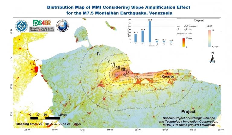
Impacted by the M7.5 Montalban earthquake (epicenter near San Felipe), approximately 498,000 people are estimated to be exposed to MMI-VII shaking, while about 368,000 and 235,000 people are estimated to be exposed to MMI-VIIl and MMI-IX shaking, respectively. Overall, more than 1.0 million people aredistributed in areas with seismic intensity of MMI-VII or higher. These intensity levels may cause significant damage to ordinary buildings, with MMI-VIIl and above being destructive. (DRS4BR, Mao WF, Wang ZQ, Wu LX et al.)

Using the NCEP GFS forecast product as meteorological input and referring to the precipitation fields generated by DRS4BR developed deep learning model, we noticed that a sustained rainfall over the epicentral region and adjacent northern coastal areas, including Caracas and La Guaira, will remain generally light to moderate during the next 0-144 hours. Cumulative total precipitation in these densely populated coastal and metropolitan zones appear limited, with no clear signal of extreme precipitation in the current forecast cycle. The relatively stable weather conditions are favorable for the implementation of post-earthquake rescue and recovery operations. (DRS4BR: Hu FY, Huang N, Jiao ZJ, Chen BY, Wu LX et al.)

 Impacted by the M7.5 Montalban earthquake in Venezuela, a large number of buildings are distributed within areas of strong to severe shaking. Based on the MMI contour analysis, approximately 2.13 million buildings are located within the MMI VI-VII interval, while about 256,000 and 180,000 buildings fall within the MMI VII-VIII and MMI VIII-IX intervals, respectively. In addition, around 116,000 buildingsare located within the MMI IX zone. Overall, more than 2.68 million buildings are distributed in areas with seismic intensity of MMI VII or higher, indicating substantial potential exposure of the built environment to damaging ground shaking. These intensity levels may cause considerable damage to ordinary buildings, with MMI VIII and above generally associated with destructive impacts.(DRS4BR, W Wang, ZM Wu, LX Wu et al.)
 Based on heterogeneous satellite data integrating multi-source SAR imagery from BC-2 (SpaceTY), GaoFen-3 (LASAC), and Sentinel-1 (ESA) satellites, we detected surface changes along the coastal region between Maiquetia and Naiguata. It was found that there are scattered significant shifts in backscattering signals in this particular area, manifesting as localized surface variations and possible building damage. Further analysis and validation are ongoing. (DRS4BR: Jiao ZJ, Chen BY, Wu LX et al.)
Based on heterogeneous 20-meter dual-polarization (VV/VH) SAR imagery fromSentinel-1 (ESA) and GaoFen-3(LASAC) satellites, significant surface changes indensely populated urban centers (including Caracas,La Guaira,and Maracay) are identified as drastic backscattering shifts driven by severe building damage, while anomalies in rugged mountainous terrains are identified as complex scattering and texture variations induced by ground deformations and triggered landslides. This rapid mobilization and analysis highlight the critical role of heterogeneous spaceborne radar data in emergency contexts. (DRS4BR:Jiao ZJ, Chen BY, Wu LX et al.)
Based on heterogeneous satellite data integrating multi-source SAR imagery from BC-2 (SpaceTY), GaoFen-3 (LASAC), and Sentinel-1 (ESA) satellites, we detected surface changes along the coastal region between Maiquetia and Naiguata. It was found that there are scattered significant shifts in backscattering signals in this particular area, manifesting as localized surface variations and possible building damage. Further analysis and validation are ongoing. (DRS4BR: Jiao ZJ, Chen BY, Wu LX et al.)
Based on heterogeneous 20-meter dual-polarization (VV/VH) SAR imagery fromSentinel-1 (ESA) and GaoFen-3(LASAC) satellites, significant surface changes indensely populated urban centers (including Caracas,La Guaira,and Maracay) are identified as drastic backscattering shifts driven by severe building damage, while anomalies in rugged mountainous terrains are identified as complex scattering and texture variations induced by ground deformations and triggered landslides. This rapid mobilization and analysis highlight the critical role of heterogeneous spaceborne radar data in emergency contexts. (DRS4BR:Jiao ZJ, Chen BY, Wu LX et al.)
 Based on heterogeneous satellite data integrating multi-source SAR imageries from LT-1A LSAR (LASAC), GaoFen-3 (LASAC), and Sentinel-1 (ESA) satellites, we detected surface changes along the coastal region including Maiquetia and Catia La Mar. The significant shifts in backscattering signals are predominantly concentrated in the area of high-rise buildings and main arterial roads, which represent the core affected areas. Further analysis and validation are ongoing. (DRS4BR: Jiao ZJ, Chen BY, Wu LX et al.)
 Impacted by the M7.5 Montalban earthquake in Venezuela, the Maiquetia mapping area shows damage to both buildings and road infrastructure. Within the mapped area, about 100 buildings were classified as collapsed and about 80 as damaged, covering roughly 0.037 km2 and 0.024 km2, respectively. The area also contains about 40 km of OSM roads, with approximately 15 damaged road sections totaling 0.62 km. Damage was mapped through visual interpretation of public news videos, field photos, and social media imagery. Damaged buildings and road sections were manually identified against satellite basemaps and OSM data, then digitized and spatially compared with building and road datasets within the Maiquetia area. (DRS4BR, CY Qu, ZM Wu, W Wang, LX Wu et al.)
 Impacted by the M7.5 Montalban earthquake in Venezuela, the Caraballeda mapping area shows damage to both buildings and road infrastructure. Damage assessment was conducted using imagery from the WorldView Legion satellite constellation, specifically the Legion-06 satellite. Within the selected area, approximately 154 buildings were classified as collapsed and about 64 buildings as damaged, with an overall affected ratio of 3.82%. Road infrastructure was also affected, with 19 road sections obstructed by collapsed buildings. The total length of obstructed roads was approximately 0.74 km, accounting for 1.40% of the road network in the selected area. Damaged buildings and obstructed road sections were visually interpreted from the WorldView Legion-06 imagery, manually digitized, and spatially compared with building and road datasets within the Caraballeda area.
 Based on three ascending and three descending Sentinel SAR images, we derived four co-seismic displacement fields, covering June 18 to June 24, June 23 to June 24, June 13 to June 25, June 18 to June 25, respectively. The maximum LOS displacement of ascending is 242mm, and minimum LOS displacement of ascending is -338mm. The minimum LOS displacement of descending is -460mm. From the displacement of the ascending and descending, this earthquake can be considered a strike-slip type, with the south side moving west and the north side moving east. (DRS4BR: Dai HY, Wu LX et al.)
 A preliminary assessment of direct economic losses due to buildings collapse and damage in the coastal region, to the north of Caracas, was finished today. The data used in this work includes the earthquake Modified Mercalli Intensity (MMI, released map-1), building damage detection results (released map-8 and map-9), as well as free access 3DGloBFP building footprints and height information. The unit reconstruction cost (315.84 USD/m²) was obtained from the Global Earthquake Mode database. Results indicate that the study area contains approximately 73,300 buildings, among which about 31,845 (43.4%) were damaged and approximately 1,140 (1.6%) collapsed. The estimated total direct building economic loss is approximately 158.0 million USD. (DRS4BR: Zeng XQ, Yu JH, Qu Y,Wu LX et al.)
Comment list ( 0 )

