Welcome to the IKCEST
Login
|
Register
English
中文
Search
Advanced search
Navigation
Home
Document
Post
Reports
Newsletters
Data
Subject database for earthquake
Subject database for drought
Subject database for flood
Subject database for frozen
Subject database for heat wave
Subject database for wild fire
Subject database for ecology & environment
Subject database for urban
Subject database for social media mining
Subject database for hurricane disaster
Regional basic database for the Belt and Road
Regional disaster database for the Belt and Road
Regional database for China-Mongolia-Russia Economic Corridor
Regional database for China-Pakistan Economic Corridor
Regional database for Bangladesh-China-India-Myanmar Economic Corridor
Maps
China Historical Disaster
Biological Disasters
Geological Disasters
Earthquake Disasters
Meteorologic Disasters
Flood Disasters
Raster Data
Vector Data
Education
Tutorial for GIS
Disaster Knowledge
Presentation
Training Video
Reference report
Disaster news Video
Science Popularization
International Training
Subject-Catalogue
Organization
Experts
Website
Application
Information Aggregation
Application Using Web GIS
Scientific Data Visulization
Natural Science Research Work
Emergency Disaster Mitigation Services
Directory
Scholar
ALL
Earthquake
Flood
Drought
Geological disaster
Forest fire
Tsunami
Extreme heat wave
Typhoon
Disaster warning
Disaster risk reduction
Sichuan-Tibet Railway
Home
Data
Publish Data Data
Data
Soil raster data in turkey quake epicentre extending 200km area
earthquake
2023-11-05
The data set is the 200km soil raster data of the epicenter of the Turkey earthquake of magnitude 7.8 (February 6, 2023), which pr...
Historical disaster data in Morocco from 1900 to 2023
Morocco
historical disaster data
earthquake
natural disaster
2023-09-19
A 6.8 magnitude earthquake struck southern Morocco on the night of the 8th local time. According to the U.S. Geological Survey (US...
Earthquake point of Morocco in 2023
Morocco
location of earthquake
earthquake
2023-09-19
According to the U.S. Geological Survey Earthquake Information Network, the earthquake occurred at 23:11 local time on the 8th (6:...
Bangladesh, China, India and Myanmar's historical earthquake datasets of 1981- 2018
China
Bangladesh
India
Myanmar
earthquake
2022-08-09
This dataset is acquired from Google news, Wikipedia , the Emergency Events Database and reference documentation by data crawl, co...
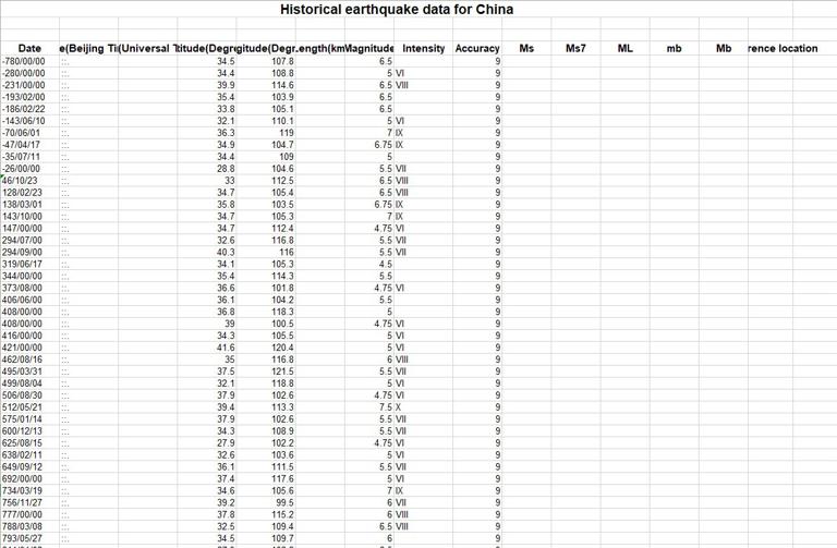
Historical earthquake data for China
history data
China
earthquake
2022-08-09
This dataset is acquired from China Earthquake Networks Center by data crawl, which describes some earthquake information about ti...
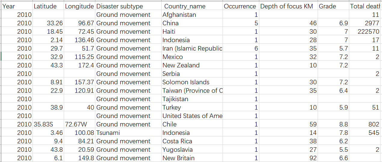
Earthquake disaster dataset (2010)
disaster
Earthquake
2022-08-09
The data set is obtained from Baidu search and reference documents by means of data capture, collection and sorting, and describes...
Southwest China's historical seismic datasets of 26AD-2015AD
earthquake
Qinghai
Sichuan
Tibet
Yunnan
2022-08-09
This dataset was acquired from China Earthquake Networks Center by data crawl, which described some earthquake information about t...
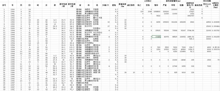
Earthquake data of 1990-2015 in Qinghai - Tibet Plateau
China
earthquake
Tibet Plateau
2022-08-09
This dataset is acquired from China Earthquake Networks Center by data crawl, which specifically describes some earthquake informa...
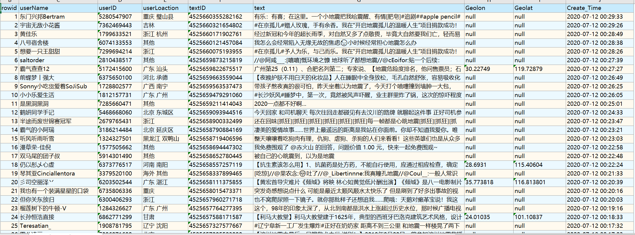
Weibo DataSet related to the Earthquake in Tangshan, China (2020)
Weibo text
earthquake
China
2022-06-17
This dataset is Weibo Data related to the earthquake on July 12, 2020 in Tangshan, China. Using web crawlers and Weibo API, origin...
Web news text dataset of earthquake in China(2005-2018)
earthquake
China
web text
2022-06-17
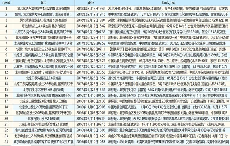
This web news text dataset of earthquake in China is gathered by a web crawler from the SINA.com, which is an online news media so...
1
Most concern
Leaf Area Index (LAI): Field Measurements, Remote Sensing Estimation and Validation Studies(2015)
Resources, Environmental and Economic Patterns and Sustainable Development Modes of Silk Road Economic Belt(2015)
The disaster scene of zhouqu mudslide in gansu province
Ecosystem, Climate and Livehood
Spring Festival travel during ice disaster in 2008
Recent articles
2026-06-24: M7.5 Venezuela Earthquake
A dataset of spring sandstorm distribution on the Mongolian Plateau (2000-2021)
China Earthquake Administration
Institute of China Seismological Bureau crustal
Cui Peng
Classified catalogue
Presentation
Training Video
Reference report
Paper
Disaster news Video
Documents
Books
Journal
Data
Subject database for hurricane disaster
Portal
Experts
Organization
Website
Biology
Climatology
Geophysics
Hydrology
Meteorology
Technology
Subject database for earthquake
Subject database for drought
Subject database for flood
Subject database for frozen
Subject database for heat wave
Subject database for wild fire
Subject database for ecology & environment
Subject database for urban
Subject database for social media mining
Regional basic database for the Belt and Road
Regional disaster database for the Belt and Road
Regional database for China-Mongolia-Russia Economic Corridor
Regional database for China-Pakistan Economic Corridor
Regional database for Bangladesh-China-India-Myanmar Economic Corridor
Data List
|
About
|
Contact Us
|
How to use
京ICP备05002838号-31
© 2008 - 2024 IKCEST All rights reserved