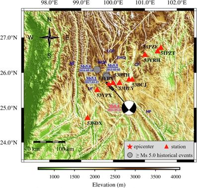
Earthquakes remain unpredictable and pose significant challenges to disaster preparedness. This study develops a rapid assessment framework for earthquake disaster losses based on physical simulations, demonstrated through analysis of the 2021 Ms 6.4 Yangbi earthquake. A finite fault source based on observed data is employed on a GPU-accelerated 3D strong ground motion simulation platform. The computational process considers the effects of 3D heterogeneous velocity structure and terrain. Subsequently, this data is incorporated into a mathematical model for earthquake disaster loss assessment derived from historical statistics, evaluating emergency response levels, fatalities, and economic losses. The inclusion of teleseismic data into this framework underscores its extensive applicability for rapid loss assessments, even in regions lacking local seismic data. Through comparisons with station observation waveforms and government-reported loss, the validity and practicality of the framework were substantiated. It plays a vital role in assisting emergency decisions, optimizing resource allocation, and further mitigating losses.

Earthquakes remain a natural disaster that cannot be fully predicted, posing significant threats to human life. Consequently, the rapid assessment of post-earthquake disaster losses provides an effective means to assist governments and social organizations in making timely emergency response decisions, thereby reducing casualties and preventing further damage. Despite advancements in technology enhancing our understanding of earthquakes, the global challenge persists in how to quickly and effectively assess disaster losses following earthquakes.
Typically, the accuracy and speed of ground motion calculations are critical factors that significantly influence both the precision and rapidity of assessments for earthquake disaster losses. Theoretically, dense networks of stations along with detailed observational data enable the prompt acquisition of high-precision ground motion measurements. For example, the Geological Survey of Japan (GSJ) has developed the rapid assessment system known as QuiQuake. Operating across the high-dense strong-motion seismograph networks K-NET and KiK-net, this system is capable of promptly releasing detailed seismic intensity distribution maps immediately following an earthquake. However, many regions worldwide lack sufficient such advanced facilities and instead rely on Ground Motion Prediction Equations (GMPEs) based on empirical methods. The datasets that underpin GMPEs frequently lack enough records from significant near-fault earthquake events. This deficiency renders these models less effective in accurately capturing the intricate impacts of near-fault zones, which are typically the primary areas of earthquake damage. Furthermore, GMPEs incorporate ergodic assumptions, which compromise their accuracy in predicting ground motions for specific areas using data from multiple sources.
The Prompt Assessment of Global Earthquakes for Response (PAGER), developed by the U.S. Geological Survey (USGS), is currently the most widely utilized system for rapid earthquake loss assessment6. The ground motion calculations within the PAGER system predominantly rely on GMPEs, supplemented by limited observational corrections. Although the primary advantage of this system is the rapid computation of ground motion on a global scale, its accuracy is less than that achieved by physical simulation methods. Conversely, physics-based numerical simulation methods for strong ground motion thoroughly incorporate the realistic effects of heterogeneous velocity media and undulating terrain on seismic wave propagation. These methods are extensively utilized in ground motion simulation and disaster analysis. With recent advancements in graphics processing unit (GPU) and supercomputing technologies, large-scale and high-resolution 3D parallel simulation techniques have progressed rapidly. These technological developments have enabled the feasibility of rapid ground motion calculations based on physical methods following earthquakes.
This study aims to explore a universal and rapid assessment framework for earthquake disaster losses based on physical simulations post-earthquake. Its objectives are to quickly estimate the seismic intensity distribution, quantitative fatalities, and direct economic losses, and to suggest activation levels for earthquake emergency response plans. The study employs the 2021 Yangbi earthquake as a case study to demonstrate the efficacy and results of the rapid assessment framework. The results illustrate that the Yangbi earthquake could potentially result in 5 fatalities, with a 65.2% probability of 0–10 fatalities. This event is likely to be classified as a “general earthquake disaster event”, corresponding to a level IV emergency response. The most probable range for economic losses resulting from this earthquake is 10–100 billion yuan, with an estimated economic loss of 48.62 billion yuan. The calculated results show a high degree of consistency with the official statistics collected after the earthquake. Additionally, the numerical simulations also align well with the observations recorded at the stations. These assessments will aid government and related agencies in making decisions for emergency response, earthquake relief operations, resource allocation, post-disaster reconstruction, and seismic insurance planning, thereby minimizing additional socio-economic losses and saving more lives.
Source:
Natural Hazards
https://www.nature.com/articles/s44304-024-00037-4 .
Provided by the IKCEST Disaster Risk Reduction Knowledge Service System
Comment list ( 0 )
