Label : desertificationMongolian Plateau
Date: 2025-06-16
View counts: 2948
Browse document: Browse document
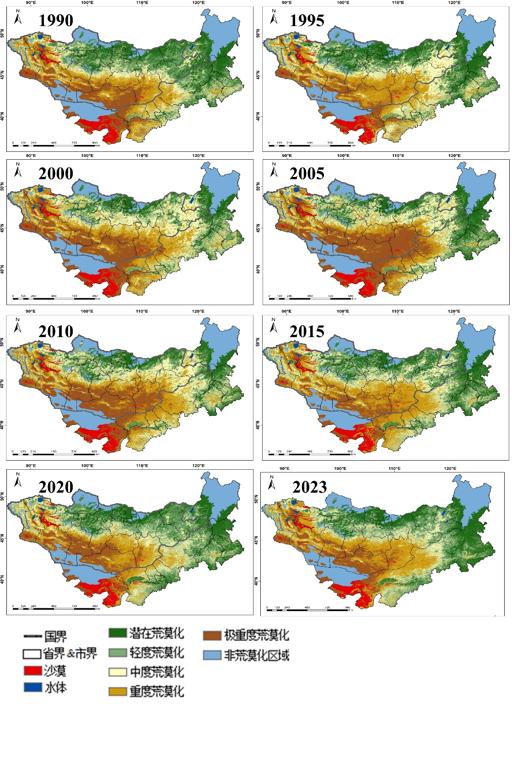
The Mongolian Plateau, representing one of the most significant arid regions in the contemporary Northern Hemisphere, is a typical area highly sensitive and vulnerable to global change while simultaneously playing a crucial role in establishing ecological security buffers for northern China and the broader expanse of northern Asia, where desertification stands as one of the most severe ecological and environmental challenges, with Mongolia itself being a global hotspot for this process. Under the combined pressures of climate change and unsustainable anthropogenic activities—including overgrazing and unregulated mining—grassland degradation and land desertification within the plateau have intensified markedly in recent decades, a trend underscored by the escalating frequency and severity of transboundary sand and dust storms (SDS) affecting both Mongolia and China, which have once again brought the desertification crisis into sharp focus. Therefore, this study utilized the Google Earth Engine (GEE) platform as the primary tool for processing remote sensing data, leveraging multi-source Earth Big Data and employing a feature-based framework coupled with machine learning techniques to conduct a refined desertification analysis, enabling the acquisition of detailed, spatially explicit desertification grade distribution maps for the Mongolian Plateau spanning 1990 to 2023 with a spatial resolution of 30 meters and a temporal interval of 5 years. This research holds substantial scientific significance and practical implications for combating desertification, enhancing ecological security, fostering cross-border cooperation, and supporting the green and sustainable socio-economic development of the Mongolian Plateau region.
Comment list ( 0 )

