On August 26, 2026, a major ice-rock avalanche occurred at high altitude in Nepal side near China-Nepal border along the Lhende river, triggering a cascading flash/flood and debris that caused severe damage to roads, bridges, and buildings along the downstream of three relatedrivers. The China DRS4BR team members of Central South University, Beijing NormalUniversity, and the Land Satellite Remote Sensing Application Center, promptly initiateddisaster assessment on impacted roads, bridges and buildings, using available satellite observations.
Multi-source pre- and post-disaster satelliteimagery, including that Sentinel-2 acquired on Aug.27, GF-1B, ZY-1E and WorldView Aug. 28, GF-1C Aug. 29, GF-1D Aug. 30, and ZY-1EAug.31, were jointly used to analyze and map the disaster situation. By comparing post-disasterobservations with pre-disaster imagery andproduct, the impacted roads, bridges and buildingswere automatically identified, and followedwith manual interpretation and checking.
We reached the followings maps and numbers in the region with usable satellite imagery:
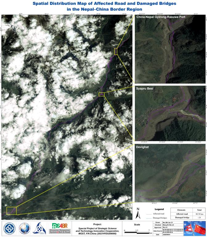
1.An approximately 80.6km long river corridor was affected in Nepal, which extended downstream from the Gyirong-Rasuwa port, passed through Rasuwagadhi, Timure, SyapruBesi, and Betrawati in Nepal, and reached to the Phirkep-Devighat.
2.A total of 24 bridges were identified as damaged, which were particularly severe for those in Syapru Besi, Bidur, and Devighat.
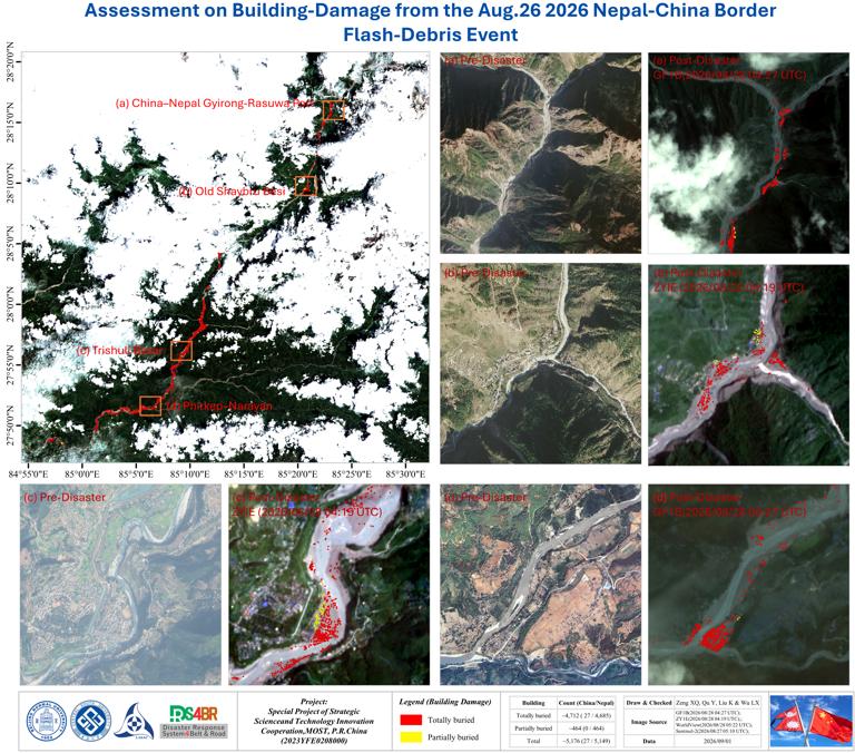
3.Approximate 5,176 independent buildings of different sizes were impacted, including 4,712 totally buried by the flash-debris brought sediments (mud and silt), and 464 partially buried.Spatial analysis indicates that 27 buildings in the Gyirong Port of Chinese side were totally buried, while 4,685 in Nepal side were totally buried.
Note that differences among different satelite observations in acquisition time, spatial resolution, cloud cover, and viewing geometry may introduce uncertainties in the disaster identification. The reported figures/numbers should therefore be considered as preliminary and will require further verification and updatesas additional high-resolution satellite imagery,close UAV observations, and field survey data become available.
16:00 Pm, Sept. 1 2026
Comment list ( 0 )

