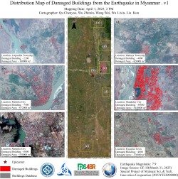
Leveraging GF-1B high-resolution satellite imagery (2-meter resolution) provided by the Land Satellite Remote Sensing Application Center, Ministry of Natural Resources of China, our team conducted a comprehensive damage assessment of buildings impacted by the March 28 Myanmar earthquake. The data revealed severe structural losses, with Mandalay City suffering the most extensive damage—50,000 buildings destroyed or compromised, covering approximately 544,000 mm2. Two zones in Meikhtila City reported significant destruction: 7,400 buildings (672,000 mm2) and 6,000 buildings (530,000 mm2). Additional damage was observed in Leipanhla Township (2,200 buildings/180,000 mm2), Madaya Township (4,000 buildings/420,000 mm2), and Kyauks Town (4,000 buildings/376,000 mm2), cumulatively exceeding 2 million square meters of affected areas.

Figure 1. Distribution Map of Damaged Buildings from the Earthquake in Myanmar
(Mapping Author: Qu Chenyao, Wu Zhimin, Wang Wei, Wu Lixin, Liu Kun)

