The Mw 7.9 earthquake that struck Myanmar's Sagaing Region on March 28, 2025, caused severe structural damage and increased the potential for secondary hazards, particularly flooding. Ground deformation, soil liquefaction, and disrupted drainage systems may exacerbate the risk of post-earthquake flooding, posing significant threats to affected communities and complicating emergency response efforts. Given the potential interplay between seismic and flood hazards, timely flood risk monitoring is crucial to mitigate further casualties and damage. In our research, the spatial-temporal distribution of daily total precipitation for the upcoming week in Myanmar was predicted using data from the Global Forecast System (GFS) and Global Precipitation Measurement (GPM), with the results shown in Fig. 1. Subsequently, precipitation data along with Sentinel-1, Sentinel-2, and Landsat series satellite imagery from 2000 to 2025 were utilized to characterize the flood behavior in April using the Knowledge-Driven Flood Intelligent Monitoring (KDFIM) algorithm. This analysis was further complemented by an assessment of potential flood susceptibility, integrating the disaster-forming environment and hazard factor, as shown in Fig. 2. Additionally, based on a System Theory-Driven Flood Risk Baseline Assessment (SDFRA) algorithm, potential future flood risks were comprehensively evaluated from the perspectives of the dangerousness of hazard-inducing factors, the sensitivity of the disaster-forming environment, and the vulnerability of the disaster-bearing

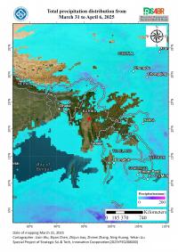
Figure 1. Future Total Precipitation Distribution from March 31 to April 6, 2025 in Myanmar and Surrounding Regions
Fig. 1 shows that no precipitation is expected over the next week, resulting in a low flood risk. This condition is particularly beneficial during the critical golden period for emergency rescue, as it allows for smoother logistics and less interference from secondary flood hazards. However, this should not lead to complacency, as the probability of precipitation is high in the coming month. Based on historical data, the potential flood susceptibility for April is predicted, as illustrated in Fig. 2.

Fig. 2 clearly illustrates that the region near Mandalay, the country’s second-largest city, exhibits high flood susceptibility, particularly in the upper reaches of the watershed. The convergence of valleys leads to significant flood risk following precipitation events. Additionally, densely populated areas along fault zones, coupled with high flood susceptibility in watershed confluence regions, pose substantial challenges for post-disaster relief and resettlement efforts. Fig. 3 provides a more intuitive visualization of future flood risk distribution, with high-risk areas clearly delineated.

Figure 3. Flood Risk Distribution in the Myanmar Earthquake-Affected Region, April 2025
Fig. 3 illustrates that the watersheds surrounding Mandalay face an extremely high flood risk in April, requiring special attention. Additionally, cities such as Shwebo, Pyinoolwin, and Meiktila, located near fault zones with relatively flat terrain, are particularly vulnerable to flooding due to potential drainage system failures caused by seismic activity. Furthermore, cities near the periphery of multiple watershed zones, including Myingyan, Monywa, and Pakokku, are highly susceptible to large-scale watershed flooding. In future disaster relief and resettlement efforts, special caution should be taken when selecting resettlement sites to mitigate flood risks and their potential impact.
(Authors: Lixin Wu, Biyan Chen, Zhijun Jiao, Zhimei Zhang, Ning Huang, Yehan Liu;Central South University, Changsha, 410012, China Corresponding author: Lixin Wu. E-mail address: wulx66@csu.edu.cn)