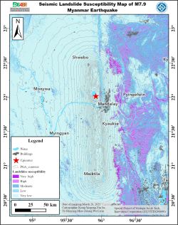
On March 28, 2025, a significant Mw7.9 earthquake struck near Mandalay in central Myanmar, posing risks of coseismic landslides in the affected areas. We evaluated landslide susceptibility by integrating multi-source geological, topographic, and hydrological data with the Newmark permanent displacement model. The model quantifies slope displacement through the integral of the difference between seismic acceleration and critical slope acceleration, categorizing the region into five risk levels (very low to very high). GIS overlay analysis of population density and building distribution revealed: (1) very high susceptibility zones in steep, weathered rock areas (e.g., Pyinoolwin and Kyaukse), requiring vigilance against landslide-induced river blockages and flooding; (2) Mandalay’s densely populated zones (14,561–38,679 people/km²) overlapping with medium-to-high susceptibility areas, highlighting severe life safety risks; (3) lower risks in Monywa and Meiktila, though secondary hazards demand preparedness. The study emphasizes prioritized infrastructure reinforcement, optimized evacuation routes, and continuous hydrogeological monitoring in high-risk zones.
_20250402065230596529.jpg)
Figure 1. Seismic Landslide Susceptibility Map of Myanmar Earthquake (overlaid with buildings)
_20250402065308352855.jpg)
Figure 2. Seismic Landslide Susceptibility Map of Myanmar Earthquake (overlaid with population)
Source: Central South University