Sedimentary processes cause large changes in riverscapes and alter river banks and margins, leading to major hazards for riverine communities. However, regional mapping of the resulting risk remains scarce, especially in remote Amazon regions. Here, we combine environmental observations with regional socioeconomic information to map erosion and sedimentation risk for Central Amazon river-floodplain communities. We combine long-term trends of open water changes (sedimentation/erosion hazard) with exposure (population size) and social vulnerability (socio-economic indices) to estimate risk at each community. Half of the region’s population, located either in uplands or floodplains, is subject to an unstable riverscape, with 18.5% of the communities affected by sedimentation processes and 26% by erosion. We identified four communities (out of 51 assessed) at very high risk, and seven at high-to-moderate risk. We highlight the need to include sedimentary processes in disaster management strategies in the changing river landscapes of the Amazon.
To our knowledge, this study presents the first regional-scale analyses of river erosion and sedimentation risk in the Amazon. We show that, in the region of the Mamirauá Reserve (around 11,000 km²) along the Amazon river-floodplain system, more than 5000 people are being impacted by erosion and sedimentation processes in both upland and floodplain environments. This population represents around half of the people that currently inhabit the area, and it highlights the need to improve basin-scale mapping of such risks, involving larger investment for understanding large-scale hazard, exposure and vulnerability of remote riverine communities.
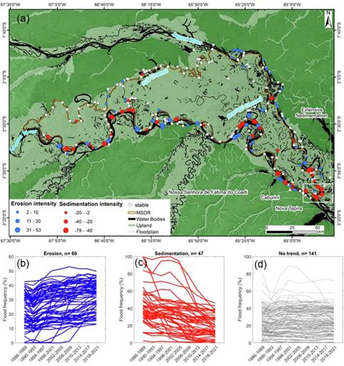
Remote sensing techniques proved very useful to map erosion and sedimentation hazard based on trend analyses of open water areas. The integration of regional-scale socioeconomic data helped to identify communities under different risk classes (very high, high, moderate, low and very low). Thus, this study stresses the possibilities of merging global-scale datasets (open water data) with regional-scale socioeconomic data (Mamirauá Institute’s census of the reserve) to provide useful information to assist disaster management strategies. Our study also highlights the need for large-scale and more consistent monitoring strategies related to these hazardous phenomena across Amazonia.
This study also contributes to the debate about practices and forms of usage of natural resources by traditional populations, since these practices are associated with local and unique knowledge about the river-floodplain environment. A deep understanding of the local ecological calendar and the particularities of the seasonal movement of river waters is fundamental for these populations to establish livelihood strategies, and improve their resilience to such disasters, e.g., through constant migration due to river erosion or sedimentation (formation of beaches). We showed that, from 254 surveyed communities, a total of 37 floodplain communities have already migrated because of these two types of natural hazards.
It is important to highlight that even though the methodology adopted here can be applied to other regions, there are several limitations that must be acknowledged. Remote sensing data may be affected, for instance, by cloud cover, geolocation errors, discontinuity in long-term series, and therefore field validation is still necessary, even for large-scale analyses. Similarly, socio-economic information is not free of uncertainties, especially regarding our assumptions about the communities’ vulnerability to risk and sedimentation risks. Nevertheless, here we present an important starting point that can guide risk mitigation efforts by regional civil defense authorities, based on global to regional-scale datasets, and especially to assist the identification of priority areas to develop more local, detailed risk surveys. We also stress that our methodology may be suitably applied to map erosion and sedimentation risk in other meandering rivers with similar channel patterns such as the Juruá and Purus rivers in the Amazon Basin. However, even within the basin, other channel patterns do exist (such as straight rivers with small meandering rates), for instance along black-water rivers, where our long-term hazard mapping approach with satellite data may not be adequate.
Finally, this study proposes that disaster risk management in the Amazon moves beyond the current paradigm that focuses mostly on increasing floods and droughts, encompassing more holistically different hazards and moving towards a compound hazard approach. The combination of multiple risks leads to major damages to local populations—this was particularly evident during the extreme 2023 drought, the largest one ever measured in the Central Amazon, when many communities became isolated due to formation of large beaches or lost their infrastructure and houses due to bank erosion. In a context of climate and other major environmental changes and degradations, including dam expansion, mining, deforestation and increased water and air pollution, the vulnerable people that inhabit the Amazonian rivers urge for better disaster management strategies.
Sources:
npj Natural Hazards
https://www.nature.com/articles/s43247-025-02058-x#Sec9 .
Provided by the IKCEST Disaster Risk Reduction Knowledge Service System
Comment list ( 0 )

