Login   |      Register
English    中文


Based on WebGIS technology, the map can be online browsing, zoom, and can also be used for different map overlay operation.

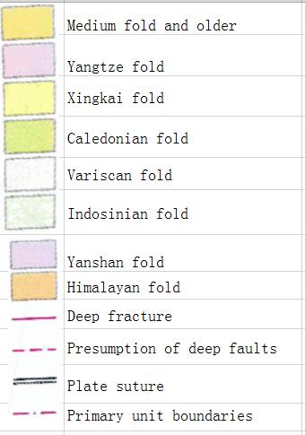
Chinese geotectonics (polycyclic theory) online map

Date: 2020-08-10  Editor: houxue2018    View counts: 6333   

Category: Others


Central point longitude
105.0
Central point latitude
40.0
Max zoom level
8
Min zoom level
4
Current zoom level
4

Map description

Chinese geotectonics (polycyclic theory) online map

The name of the construction unit represented by a number on the diagram:①Altai fold system, ②Erguna fold system, ③Upper Heilongjiang fold system, ④Nadanhada fold system, ⑤South China Sea platform
    Sign in for comments!

Comment list ( 0 )


Map evaluation
Map reference
Map overlay
Login for more operation .