Welcome to the IKCEST
Login
|
Register
English
中文
Search
Advanced search
Navigation
Home
Document
Post
Reports
Newsletters
Data
Subject database for earthquake
Subject database for drought
Subject database for flood
Subject database for frozen
Subject database for heat wave
Subject database for wild fire
Subject database for ecology & environment
Subject database for urban
Subject database for social media mining
Subject database for hurricane disaster
Regional basic database for the Belt and Road
Regional disaster database for the Belt and Road
Regional database for China-Mongolia-Russia Economic Corridor
Regional database for China-Pakistan Economic Corridor
Regional database for Bangladesh-China-India-Myanmar Economic Corridor
Maps
China Historical Disaster
Biological Disasters
Geological Disasters
Earthquake Disasters
Meteorologic Disasters
Flood Disasters
Raster Data
Vector Data
Education
Tutorial for GIS
Disaster Knowledge
Presentation
Training Video
Reference report
Disaster news Video
Science Popularization
International Training
Subject-Catalogue
Organization
Experts
Website
Application
Information Aggregation
Application Using Web GIS
Scientific Data Visulization
Natural Science Research Work
Emergency Disaster Mitigation Services
Directory
Scholar
ALL
Earthquake
Flood
Drought
Geological disaster
Forest fire
Tsunami
Extreme heat wave
Typhoon
Disaster warning
Disaster risk reduction
Sichuan-Tibet Railway
Home
Document
News and Events
Publish Document Data
News and Events
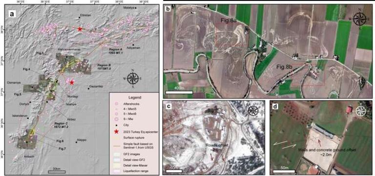
High-quality satellite imagery swiftly reveals post-earthquake details
Earthquake
Remote sensing
2023-05-31
Abstract Remote sensing imagery is widely used in disaster response due to its easy accessibility and timeliness and can clearly ...
Google’s AI-powered Flood Hub disaster alert system is now available in 80 countries
Artificial intelligence
disaster alert system
Flood Hub
2023-05-31
Abstract When faced with the possibility of a natural calamity, people in vulnerable locations can reduce the disaster management...
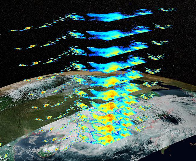
The first set of images of FY-3G released
Climate change
meteorological satellite
precipitation measurement
2023-05-31
Abstract On May 15, the first set of images of FENGYUN-3G (FY-3G), China's first precipitation measurement satellite, was release...
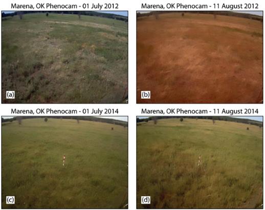
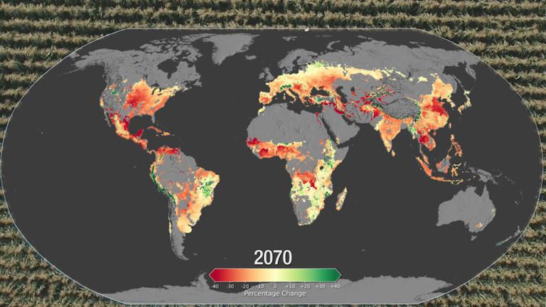
Global Flash Droughts Expected to Increase in a Warming Climate
Global Flash Droughts
Warming Climate
2023-05-31
Abstract The rapid development of unexpected drought, called flash drought, can severely impact agricultural and ecological syste...
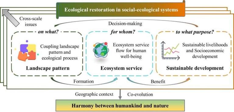
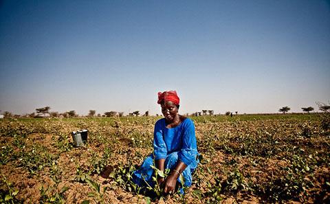
Ecological restoration for sustainable development in China
Ecological restoration
Sustainable land resource
Sustainable development
2023-04-28
Abstract China is tackling the problem of ecological restoration at the national level, seeing it as a vital component of so-call...
Scientists use AI and underwater microphones to detect tsunamis and earthquakes
Artificial intelligence
Natural disasters
earthquakes
2023-04-28
Abstract An early warning system for tsunamis and underwater earthquakes - powered by artificial intelligence - has been develope...
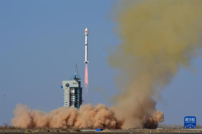
FY-3G meteorological satellite, the first precipitation measurement satellite of FY-3 series, successfully lifted off
Climate change
meteorological satellite
precipitation measurement
2023-04-28
Abstract At 9:36 a.m. on April 16, a Long March-4B rocket blasted off from the Jiuquan Satellite Launch Center in northwest China...
Shift to ‘flash droughts’ as climate warms
flash droughts
climate warms
2023-04-28
Abstract ‘Flash droughts’ have become more frequent due to human-caused climate change and this trend is predicted to accelerate ...
NASA-Funded Study to Improve Mapping, Predictability of Landslides
remote sensing
machine learning
2023-04-28
Abstract Netra Regmi, hazards geologist for the Oklahoma Geological Survey at the University of Oklahoma, is leading a study fund...
Global Climate Change Impact on Crops Expected Within 10 Years, NASA Study Finds
Global Climate change
Agricultural production
Global Food Security
2023-04-06
Abstract Climate change may affect the production of maize (corn) and wheat as early as 2030, according to a new NASA study. Conte...
Home
Previous page
12
13
14
15
16
17
18
19
20
21
Next page
End
Go to
page
Jump
Most concern
ISTIC Governing Board Chairman visited IKCEST
DRR reported to the 1st session of the second governing board and advisory committee of IKCEST
IKCEST team attended the Forum on Artificial Intelligence in Africa
The picture of Jiuzhaigou earthquake
Historical earthquake data for China
Recent articles
Evaluation of flood susceptibility through an artificial neural network-based differential evolution optimization algorithms and GIS techniques
Widespread ecological responses and cascading effects of the 2021 western North American heatwave
Climate change leads to an expansion of global drought-sensitive area
The critical role of soil moisture in compound hazards
Floods in 2025
Classified catalogue
News
Events
Natural Sciences
Humanity
Social Sciences
Technology
Products
Company
Biological
Climatological
Geophysical
Hydrological
Meteorological
Technological
Basic Knowledge
Guard against Knowledge
Scientific Knowledge
Mountain Flood Disaster Rescue
City Waterlogging Disaster Self-help
Typhoon Disaster Self-help
Data List
|
About
|
Contact Us
|
How to use
京ICP备05002838号-31
© 2008 - 2024 IKCEST All rights reserved