Label : spatio distributiondrought disasterMongolian plateau
Date: 2020-10-28
View counts: 8100
Browse document: Browse document
Download Dataset: Log in
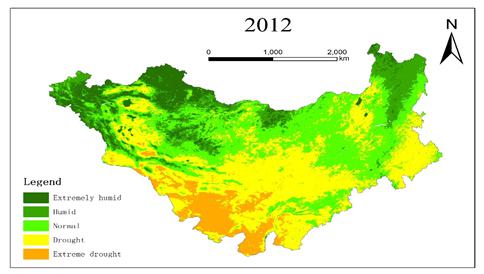
This dataset was the drought distribution data of the Mongolian plateau from 1981 to 2012. It mainly described the drought conditions of different maps and different years of the Mongolian plateau. There were 32 grid files in total. They were collected and organized by the Institute of Geographic Sciences and Natural Resources Research, Chinese Academy of Sciences. They could be used to study the occurrence and distribution of drought disasters, and provided an important basis for preventing drought disasters and reducing the negative impact of it.
Comment list ( 0 )

