Label : feature spaceMongolia PlateauDesertificationmachine learning
Date: 2025-02-19
View counts: 4357
Browse document: Browse document
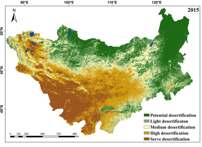
This dataset includes data on the degree of desertification in Mongolia Plateau for 2015 and 2020 . This dataset was composed of 2 raster files. They are produced by the Institute of Geographical Sciences and Natural Resources Research of the Chinese Academy of Sciences.Based on Landsat8 data with 30m resolution, the performance of various machine learning and feature space models for large-scale desertification monitoring is compared, with the gradient boosting tree model being the most adapted for desertification monitoring on the Mongolian Plateau. And based on gradient boosting tree algorithm, we complete the fine extraction of desertification in Mongolia in 2015 and 2020 with Google Earth Engine (GEE) platform. The dataset visually reflects the spatial distribution of land with different degrees of desertification in Mongolia Plateau, which can provide detailed and reliable data support for the delineation of key areas for desertification control and the formulation of restoration strategies in Mongolia Plateau, and is of great significance for the ecological environment and green sustainable development of the China-Mongolia-Russia Economic Corridor.
Comment list ( 1 )

the data is very good but it's difficulty to access
may I ask how you obtained this data?

