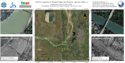
Utilizing ZY-1 high-resolution imagery (2-meter resolution) provided by the Land Satellite Remote Sensing Application Center, Ministry of Natural Resources of China, combined with advanced deep learning-based small target recognition algorithms, our team automated damage detection across bridge networks. Partial collapse of a kilometer-scale bridge (The Ava Bridge, coordinates 21.87°N, 95.99°E), where a fractured main span has obstructed river flow. Complete destruction of a 100-meter-scale unnamed bridge (coordinates 21.83°N, 95.99°E), rendering the structure impassable due to deck collapse.
 Figure 1. Pre/Post comparison of damaged bridges near Myanmar epicenter (30km)
(Mapping Author: Qu Chenyao, Wu Zhimin, Wang Wei, Wu Lixin, Liu Kun)