Welcome to the IKCEST
Login
|
Register
English
中文
Search
Advanced search
Navigation
Home
Document
Post
Reports
Newsletters
Data
Subject database for earthquake
Subject database for drought
Subject database for flood
Subject database for frozen
Subject database for heat wave
Subject database for wild fire
Subject database for ecology & environment
Subject database for urban
Subject database for social media mining
Subject database for hurricane disaster
Regional basic database for the Belt and Road
Regional disaster database for the Belt and Road
Regional database for China-Mongolia-Russia Economic Corridor
Regional database for China-Pakistan Economic Corridor
Regional database for Bangladesh-China-India-Myanmar Economic Corridor
Maps
China Historical Disaster
Biological Disasters
Geological Disasters
Earthquake Disasters
Meteorologic Disasters
Flood Disasters
Raster Data
Vector Data
Education
Tutorial for GIS
Disaster Knowledge
Presentation
Training Video
Reference report
Disaster news Video
Science Popularization
International Training
Subject-Catalogue
Organization
Experts
Website
Application
Information Aggregation
Application Using Web GIS
Scientific Data Visulization
Natural Science Research Work
Emergency Disaster Mitigation Services
Directory
Scholar
ALL
Earthquake
Flood
Drought
Geological disaster
Forest fire
Tsunami
Extreme heat wave
Typhoon
Disaster warning
Disaster risk reduction
Sichuan-Tibet Railway
Home
Subject database for earthquake
Publish Data Data
Subject database for earthquake
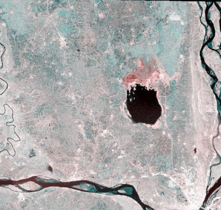
Image of Sentinel 1 in the earthquake zone of Myanmar
Remote Sensing
Sentinel1
Mynmar earthquake
2025-04-01
The dataset is the sentinel1 SAR image before the earthquake in Myanmar, with a spatial resolution of 5m and a polarization mode o...
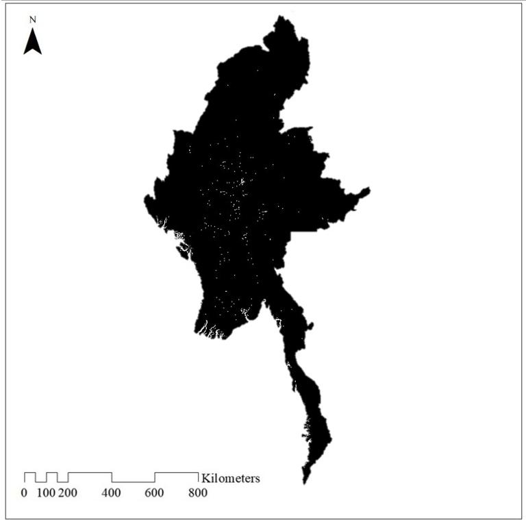
Data on residential sites in Myanmar
residential sites
Myanmar
2025-04-01
The World Settlement Footprint (WSF) 2019 is a 10m resolution binary mask outlining the extent of human settlements globally deriv...
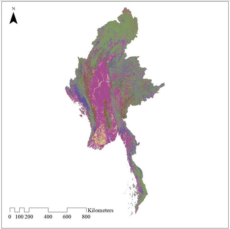
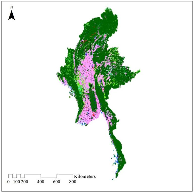
Land use data for Myanmar (300m)
landuse
landcover
Myanmar
2025-04-01
The dataset was taken from ESA's CCI project and has a resolution of approximately 300 meters. The year is 2020. The data contains...
Land use data for Myanmar (10m)
landuse
landcover
Myanmar
2025-04-01
The spatial resolution of the land use data is 10m. The data comes from ESA's 2021 global land cover classification, which include...
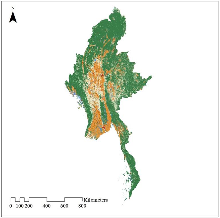
Land use data for Myanmar (30m)
landuse
landcover
Myanmar
2025-04-01
The spatial resolution of the land use dataset is 30m. The data comes from GLC_FCS30. The data uses a granular classification syst...
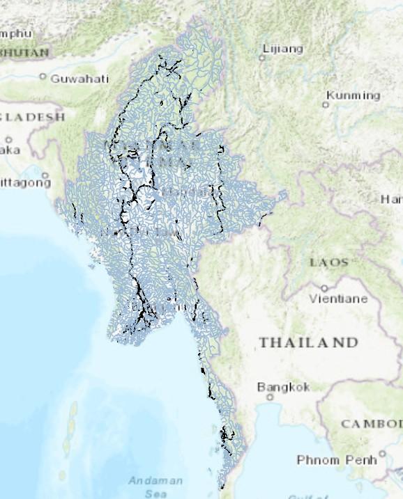
Myanmar Hydrological Data
Lake area
River boundary
myanmar
2025-04-01
The vector data on the boundaries and areas of river systems in Myanmar provides detailed geographical information on the country'...
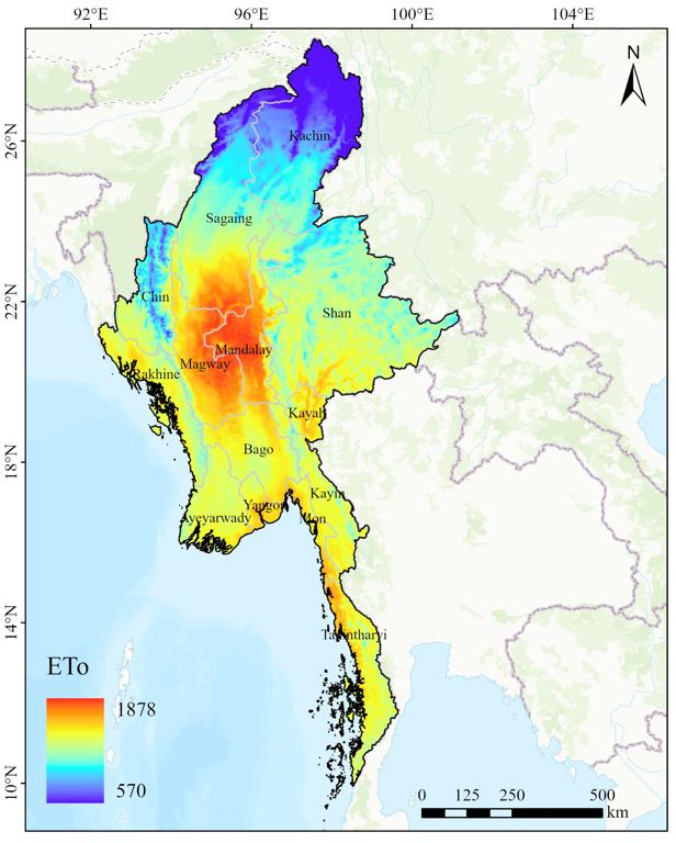
Average potential evapotranspiration (ETo) in Myanmar from 1970 to 2000
ETo
Myanmar earthquake
2025-03-31
This data can be obtained in Tiff format. Global raster datasets of average potential evapotranspiration (PET) from 1970 to 2000...
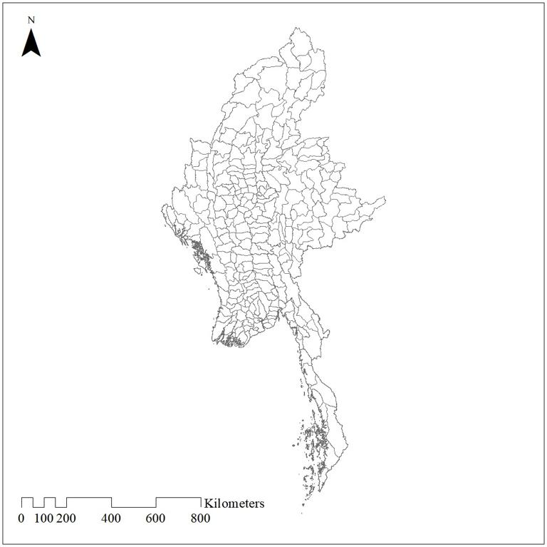
Administrative divisions of Myanmar
Myanmar
Administrative divisions
2025-03-31
The data shows the administrative boundaries of Myanmar, which is divided into seven divisions, seven states and the Union Territo...
The Weibo data text about the Myanmar earthquake in 2025
Text
Myanmar
Earthquake
Weibo
2025-03-31
The dataset comprises Weibo data text related to the Myanmar earthquake, covering detailed discussions on Weibo from 14:20 to 19:0...
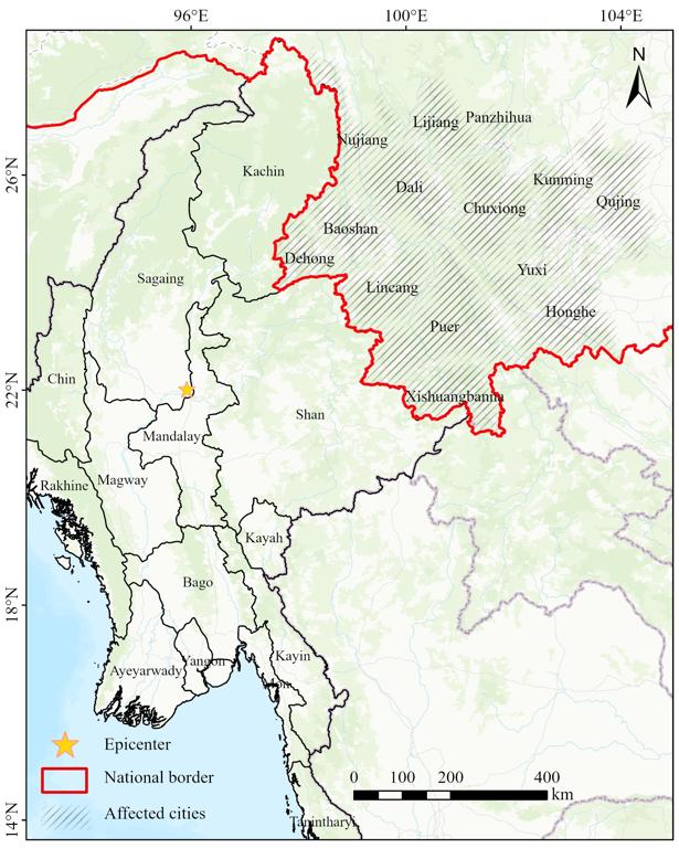
The extent of the Myanmar earthquake of the March 28, 2025 in China
Affected cities in China
Myanmar earthquake
PGA
2025-03-31
This data can be obtained in Shapefile and Flt format. This data mainly uses Peak Ground Acceleration (PGA) data from the United S...
Home
Previous page
1
2
3
4
5
6
Next page
End
Most concern
Leaf Area Index (LAI): Field Measurements, Remote Sensing Estimation and Validation Studies(2015)
Resources, Environmental and Economic Patterns and Sustainable Development Modes of Silk Road Economic Belt(2015)
The disaster scene of zhouqu mudslide in gansu province
Ecosystem, Climate and Livehood
Spring Festival travel during ice disaster in 2008
Recent articles
2025-10-29: Belgorod Reservoir Dam Damage had Triggered Water Shrinks in Upstream while Water Expands in Downstream
2025-10-13: Flood situation in northern Vietnam from October 9 to 12,2025
2025-07-07: SO₂ plume distribution from Lewotobi Volcano, Indonesia,observed by TROPOMI
Drought Disaster and High Temperature in Nanjing 236-2020
Mongolian Drought Distribution Dataset
Classified catalogue
Presentation
Training Video
Reference report
Paper
Disaster news Video
Documents
Books
Journal
Subject database for hurricane disaster
Data
Portal
Experts
Organization
Website
Biology
Climatology
Geophysics
Hydrology
Meteorology
Technology
Subject database for earthquake
Subject database for drought
Subject database for flood
Subject database for frozen
Subject database for heat wave
Subject database for wild fire
Subject database for ecology & environment
Subject database for urban
Subject database for social media mining
Regional basic database for the Belt and Road
Regional disaster database for the Belt and Road
Regional database for China-Mongolia-Russia Economic Corridor
Regional database for China-Pakistan Economic Corridor
Regional database for Bangladesh-China-India-Myanmar Economic Corridor
Data List
|
About
|
Contact Us
|
How to use
京ICP备05002838号-31
© 2008 - 2024 IKCEST All rights reserved